Scott Martin | February 15, 2025 @ 9:31 pm
Category: Alabama’s Weather, ALL POSTS, Severe Weather, Social Media


Bill Murray (Weather Historian)
Page 2
 Severe Weather Live Stream
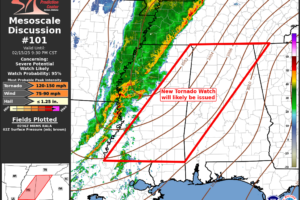 New SPC tornado watch discussion details
 Here is the latest on today’s severe weather threat.
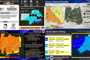 Here are the latest timing updates from each of the four NWS offices that serve the state of Alabama.
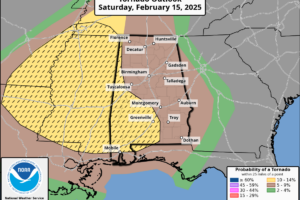
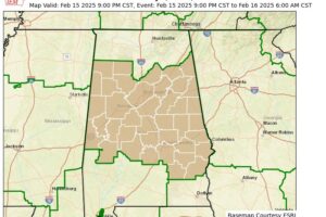
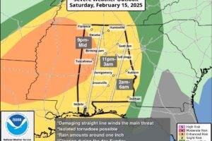
 The level 3/5 enhanced severe weather risk has been expanded to include more of west and south Alabama
 Wind advisory now in effect statewide
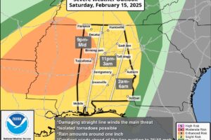
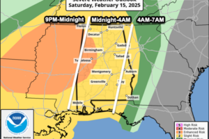
 Severe storm timing looks to be between 9PM tonight and 4AM Sunday morning, so be sure to have a way to get weather alerts while you’re sleeping.
 A wind advisory has been issued for northern Alabama
 PLEASANT WINTER DAY: Temperatures are in the 50s and 60s across Alabama this afternoon with a good supply of sunshine. Clouds will increase overnight; the low early tomorrow will be in the 45-55 degree range.
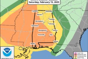
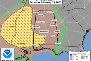
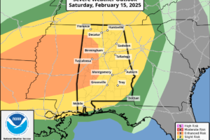
 The SPC maintains an “enhanced risk” (level 3/5) for parts of West Alabama, with a “slight risk” (level 2/5) for the rest of the state. The greatest chance for severe storms will be to the west tomorrow, and that is where the tornado threat will be highest, especially across North Mississippi, but the storms to our west will congeal into a line of strong and severe storms.
 COLD START: Temperatures are in the 20s and 30s over the northern 2/3 of Alabama this morning, with low 40s along the Gulf Coast. Look for a sunny sky today with a high in the 57-65 degree range.
 COLDER: Colder, drier air continues to roll into Alabama this afternoon; the sky is partly to mostly sunny. Tonight will be fair and cold.
 A gradually clearing sky today as drier air moves into the state. Temperatures this afternoon are in the low to mid 50s for much of North and Central Alabama; portions of the Tennessee Valley will remain in the 40s today.
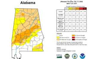 An odd look to this weeks drought monitor. We explain why and when you can expect it to change.
