ATLANTA — A Weather Impact Alert is in effect for the Atlanta area early Sunday for a powerful cold front that is prompting a line of severe storms to cut across the state.
The main threat with these storms has been gusty, potentially damaging winds. A gust of nearly 70mph was reported before 5 a.m. at Hartsfield-Jackson Atlanta International Airport.
Tornado Warnings have impacted wide stretches of southwestern and southeastern metro Atlanta, and at least two radar-confirmed tornadoes were reported in the Monticello area. Severe Thunderstorm Warnings and intense storms were reported in the City of Atlanta and inner metro, as well. Thousands have been left without power.
Tornado Warnings also were issued in Columbus, Macon and the Lake Hartwell areas, showing the wide stretch of the impact of these storms.
- When: Saturday overnight through Sunday morning from 3 a.m. until 8 a.m.
- Impact: Heavy rain and thunderstorms. We’re also watching the potential for strong to severe thunderstorms.
- Need: A way to get weather alerts that will wake you if necessary.
We’re tracking the latest updates below:
6:00 a.m. | That line is still pushing out east, and there is a Severe Thunderstorm Warning that was just issued for Putnam County until 7 a.m.
5:58 a.m. | Remarkable power outage numbers — nearly 100,00 outages in metro Atlanta with Georgia EMC and close to 100,000 Georgia Power customers without power between Fulton, DeKalb, Cobb, Clayton and Gwinnett counties.
5:50 a.m. | The Tornado Warning north of Eatonton is expired now. There’s also an active one issued about 10 minutes ago for the Macon area.
FFC expires Tornado Warning for Greene, Morgan, Putnam [GA] https://t.co/wteqpIONEQ pic.twitter.com/lqC8qDL8mk
— IEMBot FFC (@iembot_ffc) February 16, 2025
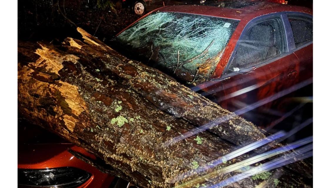
5:45 a.m. | Bill Honea in our 11Alive Weather Impact Team Facebook group sends along a photo of a tree down on a car in Newnan.

5:43 a.m. | The line is continuing to move farther east and the active storm threat is over for most of metro Atlanta. But a lot of trees down, lot of power outages.
5:39 a.m. | And this third updated Tornado Warning continuing for Greene, Jasper, Morgan, Putnam:
FFC continues Tornado Warning [tornado: RADAR INDICATED, hail: <.75 IN] for Greene, Jasper, Morgan, Putnam [GA] till 6:00 AM EST https://t.co/kylqrSihTm pic.twitter.com/4oQlQrVFwR
— IEMBot FFC (@iembot_ffc) February 16, 2025
5:37 a.m. | There’s also this updated Tornado Warning for Jasper and Morgan (5:41 a.m. update: This one has expired):
FFC updates Tornado Warning [tornado: RADAR INDICATED, hail: <.75 IN] (cancels Butts, Henry, Newton [GA], continues Jasper, Morgan [GA]) till 5:45 AM EST https://t.co/bBkUAvATxn pic.twitter.com/jQAEPIZyS3
— IEMBot FFC (@iembot_ffc) February 16, 2025
5:37 a.m. | We have an updated Tornado warning for Jasper, Jones and Putnam counties:
FFC updates Tornado Warning [tornado: RADAR INDICATED, hail: <.75 IN] (cancels Butts, Lamar, Monroe [GA], continues Jasper, Jones, Putnam [GA]) till 6:00 AM EST https://t.co/Gsp1iToYng pic.twitter.com/mm5IDQtQS0
— IEMBot FFC (@iembot_ffc) February 16, 2025
5:28 a.m. | That system, with two radar-confirmed tornadoes, now has a Tornado Warning for Greene, Jasper, Morgan, Putnam counties until 6 a.m.
FFC issues Tornado Warning [tornado: OBSERVED, hail: <.75 IN] for Greene, Jasper, Morgan, Putnam [GA] till 6:00 AM EST https://t.co/i9mivAZJpW pic.twitter.com/zDZA2jk5c9
— IEMBot FFC (@iembot_ffc) February 16, 2025
5:28 a.m. | Also a radar-confirmed tornado north of Monticello.
5:26 a.m. | We’re hearing of a radar-confirmed tornado near Monticello, Georgia in Jasper County.
5:22 a.m. | An updated look at the track on the system with the Tornado Warning active in Butts, Henry, Jasper, Morgan, Newton counties:
FFC continues Tornado Warning [tornado: RADAR INDICATED, hail: <.75 IN] for Butts, Henry, Jasper, Morgan, Newton [GA] till 5:45 AM EST https://t.co/6jVlNaWVfn pic.twitter.com/o0TTd5Eiif
— IEMBot FFC (@iembot_ffc) February 16, 2025
5:13 a.m. | And yet another Tornado Warning including parts of northeast Georgia — Franklin, Stephens, Hart counties.
Tornado Warning including Anderson SC, Clemson SC and Central SC until 5:45 AM EST pic.twitter.com/bdsuNuV0rt
— NWS GSP (@NWSGSP) February 16, 2025
5:11 a.m. | Another Tornado Warning for Jasper, Butts, Lamar, Putnam counties until 6 a.m.
FFC issues Tornado Warning [tornado: RADAR INDICATED, hail: <.75 IN] for Butts, Jasper, Jones, Lamar, Monroe, Putnam [GA] till 6:00 AM EST https://t.co/zpZH5qPvtq pic.twitter.com/Lxvs5yU4Pe
— IEMBot FFC (@iembot_ffc) February 16, 2025
5:08 a.m. | New Tornado Warning for Morgan, Jasper, Henry, Newton, Butts counties until 5:45 a.m. Locust Grove part of this one.
Tornado Warning including Locust Grove GA, Rutledge GA and Newborn GA until 5:45 AM EST pic.twitter.com/yrMl7Viy9D
— NWS Atlanta (@NWSAtlanta) February 16, 2025
5:07 a.m. | Updated Tornado Warning now includes Morgan County as it moves east out of Henry County.
FFC updates Tornado Warning [tornado: RADAR INDICATED, hail: <.75 IN] (cancels Clayton, DeKalb, Henry, Jasper [GA], continues Morgan, Newton, Rockdale, Walton [GA]) till 5:15 AM EST https://t.co/2vMOjNf6R7 pic.twitter.com/CSZgXeu2ET
— IEMBot FFC (@iembot_ffc) February 16, 2025
5:06 a.m. | Severe Thunderstorm Warning now with Jasper, Pike, Upson, Henry, Newton, Butts, Lamar, Putnam and Spalding counties until 6 a.m.
5:05 a.m. | 11Alive Chief Meteorologist is looking at Conyers, Covington and Social Circle for the active tornado warning.
5:04 a.m. | There was a system also moving up through the Columbus area and that has now brought a severe thunderstorm warning to Upson County in our viewing area until 6 a.m. Separately, in north Georgia now Habersham County also has a severe thunderstorm warning until 5:30 a.m.
4:56 a.m. | Better look at the latest Tornado Warning map. Heads up for Stockbridge, Conyers and Covington:
Tornado Warning including Stockbridge GA, Conyers GA and Covington GA until 5:15 AM EST pic.twitter.com/fMfw4Xo5ed
— NWS Atlanta (@NWSAtlanta) February 16, 2025
4:55 a.m. | 70mph wind gust also reported at Hartsfield-Jackson Atlanta International Airport.
4:52 a.m. | Tornado Warning for Clayton, DeKalb, Henry, Jasper, Newton, Rockdale and Walton counties:
FFC issues Tornado Warning [tornado: RADAR INDICATED, hail: <.75 IN] for Clayton, DeKalb, Henry, Jasper, Morgan, Newton, Rockdale, Walton [GA] till 5:15 AM EST https://t.co/xHNyFj4lMK pic.twitter.com/kdEp6nx8mM
— IEMBot FFC (@iembot_ffc) February 16, 2025
4:50 a.m. | LOTS of power outages in Fulton and DeKalb counties. See the Georgia Power map here.
4:48 a.m. | As the main line keeps moving east, a new Severe Thunderstorm Warning is in effect for Clarke, Hall, Rockdale, Butts, Oconee, Jackson, DeKalb, Morgan, Jasper, Walton, Henry, Newton, Clayton, Gwinnett and Barrow counties until 5:30 a.m.
Severe Thunderstorm Warning including Redan GA, Lawrenceville GA and Stockbridge GA until 5:30 AM EST pic.twitter.com/qcwhJWIJhd
— NWS Atlanta (@NWSAtlanta) February 16, 2025
4:43 a.m. | A wind gust of 71 miles per hour was recorded at Mercedes-Benz Stadium in Downtown Atlanta.
4:41 a.m. | This is technically not in our viewing area but there’s a new Tornado Warning for the Columbus area, including Chattahoochee, Harris, Muscogee and Talbot counties. That one will be in effect until 5:15 a.m..
4:40 a.m. | 11Alive Chief Meteorologist Chris Holcomb now advising anyone around Senoia to get to their tornado safe place
4:38 a.m. | Fulton County Emergency Management Agency saying there are trees down around the county.
4:36 a.m. | Latest look at the continuing Tornado Warning until 5 a.m.
Tornado Warning continues for Peachtree City GA, Senoia GA and Luthersville GA until 5:00 AM EST pic.twitter.com/FLdiDTPimp
— NWS Atlanta (@NWSAtlanta) February 16, 2025
4:36 a.m. | New Severe Thunderstorm Warning for Clayton, Coweta, Fayette, Harris, Henry, Lamar, Meriwether, Pike, Spalding, Talbot, Troup and Upson counties until 5:15 a.m.
Severe Thunderstorm Warning including Peachtree City GA, Griffin GA and Thomaston GA until 5:15 AM EST pic.twitter.com/eIjHqJarx8
— NWS Atlanta (@NWSAtlanta) February 16, 2025
4:35 a.m. | The newer tornado warning has been canceled for Troup County.
4:32 a.m. | 11Alive Chief Meteorologist Chris Holcomb reports a doppler radar-indicated potential rotation down moving between Grantville and Luthersville.
4:31 a.m. | Here’s a tighter map on that latest Severe Thunderstorm Warning that includes all of Atlanta:
Severe Thunderstorm Warning including Atlanta GA, Sandy Springs GA and Roswell GA until 5:15 AM EST pic.twitter.com/e5gmr6f8rI
— NWS Atlanta (@NWSAtlanta) February 16, 2025
4:29 a.m. | Also have a new Severe Thunderstorm Warning impacting the inner metro including Barrow, Clayton, Cobb, Coweta, DeKalb, Fayette, Forsyth, Fulton, Gwinnett, Henry, Rockdale and Walton counties until 5:15 a.m.
FFC issues Severe Thunderstorm Warning [tornado: POSSIBLE, wind: 60 MPH (RADAR INDICATED), hail: <.75 IN (RADAR INDICATED)] for Barrow, Clayton, Cobb, Coweta, DeKalb, Fayette, Forsyth, Fulton, Gwinnett, Henry, Rockdale, Walton [GA] till 5:15 AM EST https://t.co/ktVPtD9WpC pic.twitter.com/XhWN4B9I48
— IEMBot FFC (@iembot_ffc) February 16, 2025
4:25 a.m. | Tornado Warning for Coweta, Fayette, Meriwether, Spalding, Troup counties until 5 a.m. Hogansville, Peachtree City, Senoia among the cities in this one:
Tornado Warning including Peachtree City GA, Senoia GA and Hogansville GA until 5:00 AM EST pic.twitter.com/NNi8mRCVHa
— NWS Atlanta (@NWSAtlanta) February 16, 2025
4:21 a.m. | The tornado warning down in the Hogansville/Grantville area is continuing through 4:45 a.m.
Tornado Warning continues for Hogansville GA, Grantville GA and Greenville GA until 4:45 AM EST pic.twitter.com/DXmML07Twl
— NWS Atlanta (@NWSAtlanta) February 16, 2025
Tornado Warning continues for Hogansville GA, Grantville GA and Greenville GA until 4:45 AM EST pic.twitter.com/DXmML07Twl
— NWS Atlanta (@NWSAtlanta) February 16, 2025
4:20 a.m. | An earlier Severe Thunderstorm Warning for Smyrna, Marietta and Sandy Springs as well as parts north and south is continuing through 4:45 a.m.
4:18 a.m. | The system moving east across the area of the tornado warning appears as if it will soon be entering Hogansville. Stay up-to-the-minute with 11Alive Chief Meteorologist Chris Holcomb in the stream above this story.
4:13 a.m. | New severe thunderstorm warning for Cherokee, Dawson, Forsyth, Fulton, Lumpkin, Pickens counties, including parts of north Fulton such as Alpharetta.
Severe Thunderstorm Warning including Alpharetta GA, Milton GA and Woodstock GA until 4:45 AM EST pic.twitter.com/pi5Qjnwrs2
— NWS Atlanta (@NWSAtlanta) February 16, 2025
4:10 a.m. | The tornado warning has been canceled just for Pike County.
4:05 a.m. | Another look at the map of the tornado warning:
Tornado Warning including Hogansville GA, Grantville GA and Franklin GA until 4:45 AM EST pic.twitter.com/S0RtNmjBTo
— NWS Atlanta (@NWSAtlanta) February 16, 2025
4:05 a.m. | Tornado warning issued for Coweta, Heard, Meriwether, Pike and Troup counties until 4:45 a.m.
FFC issues Tornado Warning [tornado: RADAR INDICATED, hail: 0.00 IN] for Coweta, Heard, Meriwether, Pike, Troup [GA] till 4:45 AM EST https://t.co/EbCAKOInkm pic.twitter.com/14ssU6yBzo
— IEMBot FFC (@iembot_ffc) February 16, 2025
3:57 a.m. | The latest severe thunderstorm warning issued is in effect for Carroll, Cobb, Coweta, Douglas, Fulton, Heard and Paulding counties until 4:45 a.m. Marietta, Smyrna, Sandy Springs and some parts of Atlanta included in this one:
Severe Thunderstorm Warning including Sandy Springs GA, Marietta GA and Smyrna GA until 4:45 AM EST pic.twitter.com/aSUSrGw2qg
— NWS Atlanta (@NWSAtlanta) February 16, 2025
3:45 a.m. | A new severe thunderstorm warning is now in effect, this time for the southern part of the Atlanta market, for Coweta, Harris, Heard, Meriwether and Troup counties until 4:30 a.m.
3:40 a.m. | A new round of severe thunderstorm warnings has been issued for parts of Bartow, Cherokee, Cobb, Fannin, Floyd, Gilmer, Gordon, Murray, Paulding, Pickens, Polk and Whitfield counties until 4:30 a.m.
3:29 a.m. | In just a matter of minutes, 11Alive’s tower cam captured how conditions deteriorated rapidly in Rome — from flags barely flapping to a torrential downpour.
3:20 a.m. | A new severe thunderstorm warning is in effect for parts of Carroll, Douglas, Haralson, Heard, Paulding and Polk counties until 4:00 a.m.
3:17 a.m. | The tornado warning has expired for Walker County, as well.
3:02 a.m. | The tornado warning has been canceled for Dade County, but it remains in effect for Walker County.
3 a.m. | A Severe Thunderstorm Warning is in effect until 3:45 a.m. for Bartow, Chattooga, Floyd, Gilmer, Gordon, Floyd and Polk counties.
2:45 a.m. | The National Weather Service issued a tornado warning for Dade and Walker counties in extreme north Georgia until 3:30 a.m.
2:35 a.m. | 11Alive Weather Impact Chief Meteorologist Chris Holcomb is giving a live update, monitoring several active tornado and severe thunderstorm warnings in Alabama.
2:13 a.m. | A severe thunderstorm warning is in effect for parts of Chattooga, Gordon and Floyd counties until 3 a.m.
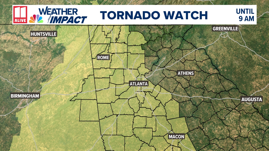
2 a.m. | A tornado watch is in effect from 2:05 a.m. to 9:00 a.m. for the following counties:
- Bartow County, GA
- Carroll County, GA
- Cherokee County, GA
- Chattooga County, GA
- Clayton County, GA
- Cobb County, GA
- Coweta County, GA
- DeKalb County, GA
- Douglas County, GA
- Fayette County, GA
- Floyd County, GA
- Fulton County, GA
- Gilmer County, GA
- Gordon County, GA
- Haralson County, GA
- Heard County, GA
- Henry County, GA
- Jasper County, GA
- Lamar County, GA
- Meriwether County, GA
- Newton County, GA
- Paulding County, GA
- Pickens County, GA
- Pike County, GA
- Polk County, GA
- Rockdale County, GA
- Spalding County, GA
- Troup County, GA
- Upson County, GA

DOWNLOAD THE 11ALIVE APP:
- Download the app on your Apple or Android device.
- Set up weather notifications by clicking the Gear icon in the upper right corner of the app. Select Notification -> Notification Settings -> Severe Weather Alerts -> Toggle the Severe Weather Alerts button to the right to turn alerts on.
- Send photos and videos through the app by selecting the Near Me feature on the bottom right task bar of the app and entering your information.
TEXT YOUR WEATHER PHOTOS TO US: 404-885-7600
JOIN THE 11ALIVE WEATHER IMPACT FACEBOOK GROUP: Nearly 10,000 metro Atlanta and north Georgia weather enthusiasts share their weather photos every day. Click here to join the group!
